

- This event has passed.
Trail Challenge 2019
June 1, 2019 @ 12:00 am - June 30, 2019 @ 11:30 pm
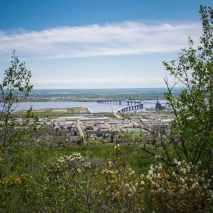
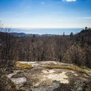
The Trail Challenge is back for 2019! Despite the late start and May snow, we are excited to hit the trails. The guidelines are the same as years past: complete all nine hikes listed below and take photos along the way as proof to get a free Osprey Daylite! These photos should be of notable spots along the trail, like the views of Lake Superior from the top of Carlton Peak or the Poplar River valley falling below the overlook. Upload your photos to Instagram or Facebook, tag @trailfitters in the photo, and use #trailchallenge in the description so we can see your awesome photos! If you are not into social media, simply bring in the photos to Trailfitters and show an associate to claim your prize. New this year, we will have patches and stickers to go along with the Osprey Daylite for finishers!
Good luck and happy trails!
Easy:
Brewer Loop (4 miles)
Trailhead: https://goo.gl/maps/97W5YPPxeV9uWczi7
Park at the Highland/Getchall Trailhead and head east over Keene Creek, following the blue blazes of the SHT. Cross Skyline Rd and make your way to the spur trail intersection where the loop begins. Take your pick of which direction to go as you loop around Brewer Park and return to your starting point. NOTE: SHTA crews will be at work rerouting the trail from the loop to the Haines Rd Trailhead. Please be aware and use caution.
Martin Road-Vermillion Road (2.8)
Trailhead: https://goo.gl/maps/Vcvve84XGgo99wUg6
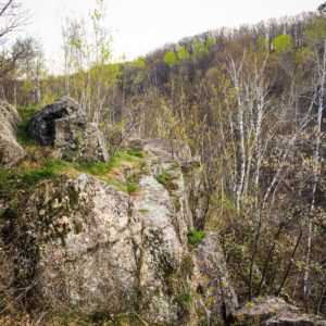
From the Martin Road Trailhead, make your way south through the carnage of the 2016 windstorm. Crossing over Pleasant View Road brings you the best views as you follow the top of rocky outcroppings above the creek bed below. Once you hit dirt on Vermillion Road, turn around and return to your car.
Micmac Lake (3.5)
Trailhead: https://goo.gl/maps/SJSFr6vm8Zb4nfVM7
Located next to Lax Lake on the north side of Tettegouche State Park, follow this meandering trail to a rewarding view from the other side of the park! Leave your car at the trailhead on Lax Lake Road and venture south, following the path into Tettegouche. The rustic cabins on Micmac Lake mark the turnaround point and a great spot for a quick snack!
Moderate:
Split Rock Lookout (3 miles)
Trailhead: https://goo.gl/maps/yY9odW5aKJW1BA179
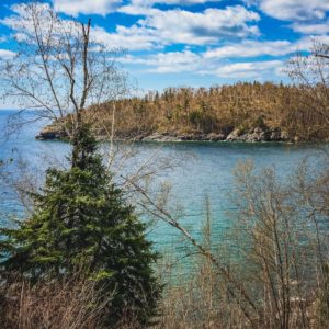
The parking lot at the mouth of the Split Rock River sits above a quaint bay where your hike starts. Head towards the lake, instead of dipping into the woods on the SHT, and cross the river before a right turn will lead you along the shores of Lake Superior. Follow Corundum Point Trail along the shore, up the stairs to dramatic views of the lake, and finally following the Day Hill Trail back to the paved Gitchi Gammi Trail. Follow the path to the Gitchi-Gami Trail, which leads back to the trailhead.
Carlton Peak (3.4)
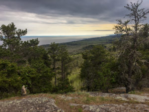
Trailhead: https://goo.gl/maps/FSojvU8hLq6V3JSt7
This tried and true North Shore hike starts a couple miles up the Sawbill Trail at the Britton Peak Trailhead. Leave the lot heading southwest on the SHT and cross over the road as the trail gradually climbs through the woods, rocky outcroppings, and expansive vistas until a spur trail will lead you up to the top of Carlton Peak. Take a short detour on the Ted Tofte spur trail for another breathtaking view of Tofte and Lake Superior below.
McCarthy Creek Campsite (7)
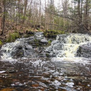
Trailhead: https://goo.gl/maps/PrtK89pgndn4kcRk9 or https://goo.gl/maps/fLNVh1vbWkBPvr5B8
Choose your own adventure as you have the options of starting this hike from the Rossini Road TH or Lake County’s Demonstration Forest. The McCarthy Creek Campsite falls almost directly between the two trailheads and sits beside the cutest waterfall on the trail. Start out north from the Rossini Road TH on the SHT through a former logging site and enjoy the views until you get to the campsite 3.5 miles later. Or follow spur trail signs through the Demonstration Forest until you intersect with the main SHT, where a left turn will lead you through the woods to the destination. If you coordinate with a friend, having a car at both ends is a great way to cover this whole section and take everything in!
Difficult:
Horseshoe Ridge (8 miles)
Trailhead: https://goo.gl/maps/asXCjhq5xair4vPs7 or https://goo.gl/maps/zyT2mhw9ZSehsfY4A
Prepare to get dirty on this hike, as we think it is the most difficult of the bunch! Parking at the Caribou River Wayside off Hwy 61 will have you heading up the hill on the SHT towards Crosby Manitou and through one of the most infamous mud pits on the trail. Your effort to get up to Horseshoe Ridge will be rewarded with a long descent back to the TH. If you choose to get to Horseshoe Ridge via Crosby Manitou’s main entrance off Cramer Rd, you will have shorter, steeper climbs and descents to get you to the ridge. Either way will leave you short of breath as you take in the view from an overlook just north (closer to Crosby Manitou SP) of the Horseshoe Ridge Campsite on the SHT.
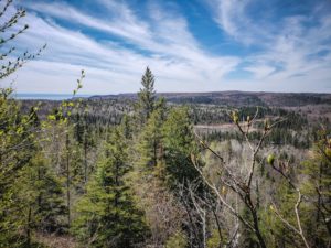
Poplar River Overlook (5)
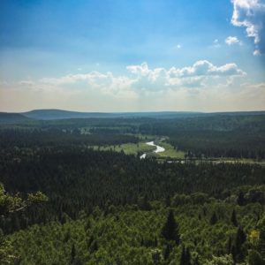
Trailhead: https://goo.gl/maps/QwwWKk1YzMm5TUoTA
The northernmost hike of our challenge starts at the Caribou Lake TH located 4 miles up the Caribou Trail outside the town of Lutsen. Venture out of the TH on the SHT spur trail southwest to the main trail. Turn right at the intersection, where you will pass the East and West Lake Agnes campsites. The Poplar River Overlook is approximately 2.5 miles from the trailhead, and you will know you have reached the right spot when you see the Poplar River unfold in the valley below.
Raven Rock (7.2)
Trailhead: https://goo.gl/maps/huVdUmsZnc1iWkDR8
Located in Tettagouche State Park, Raven Rock is a fun hike that leads you past the High Falls of the Baptism River and up a newly constructed staircase making “The Drainpipe” much more accessible. Park at the SHT Trailhead off Hwy 1 and follow the spur to the main trail, where a left turn will lead you toward the river and your eventual destination. Once crossing over the Baptism, continue uphill on the SHT to the Raven Rock spur trail, where views of the lake and Sawtooth Mountains await.